
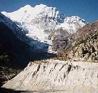
Annapurna Circuit, Nepal - Oct 1995
In October/November 1995 I hiked the Annapurna Circuit and Sanctuary in
Nepal. The circuit is a 200 mile journey around the Annapurna Himal,
up the Marsyangdi River valley to Thorong La, a 17,700' pass, and down
to the Khali Gandaki River valley. I also went up to the Annapurna
Sanctuary, a high bowl in the middle of the Annapurna Himal, surrounded
by 7000 and 8000 meter peaks on all sides. Along the way we traveled
through dense bamboo forests, arid mountain villages, high desolate
alpine terrain, and saw fields, river valleys, temples, towns, and
met wonderful travelers and locals.
Kathmandu 10/5-10/7
 We arrived in Kathmandu on 10/5/95 after
spending two unplanned days in
Bangkok due to airline problems. Put plenty of extra time in your
schedule to be safe. Our group was
Catherine, Peter, me, and Sally. From
the airport, the van from the
Tibet Guest House
picked us up and took us to Thamel, the
tourist quarter of
Kathmandu. We got our trekking permits first thing in the
morning the next day (Friday) because everything was closing at noon for
a two day holiday. Then we spent some time shopping for clothes and
other stuff. The streets are full of shops that
sell clothes, t-shirts, jewelry, books, food, and any other thing you
can imagine. There are lots of street hawkers selling Gurka knives,
Tiger Balm, and drugs. The streets are full of bicycles,
rickshaws, cars, and vans. It's exciting.
We arrived in Kathmandu on 10/5/95 after
spending two unplanned days in
Bangkok due to airline problems. Put plenty of extra time in your
schedule to be safe. Our group was
Catherine, Peter, me, and Sally. From
the airport, the van from the
Tibet Guest House
picked us up and took us to Thamel, the
tourist quarter of
Kathmandu. We got our trekking permits first thing in the
morning the next day (Friday) because everything was closing at noon for
a two day holiday. Then we spent some time shopping for clothes and
other stuff. The streets are full of shops that
sell clothes, t-shirts, jewelry, books, food, and any other thing you
can imagine. There are lots of street hawkers selling Gurka knives,
Tiger Balm, and drugs. The streets are full of bicycles,
rickshaws, cars, and vans. It's exciting.
The city was somewhat overwhelming for me at first. I've never been to
southeast Asia before, and the sights, sounds, and smells can be
bewildering. But I always felt safe in Thamel. There are westerners
everywhere you look, most of the signs are in English, and people are
friendly and courteous, for the most part. Some salespeople are pushy,
but that's part of the charm. We took a walk to
Durbar Square, a collection of
temples and shrines. We
wandered a bit through non-tourist areas and had a great time.
Pokhara 10/7-10/9
 After two days in Kathmandu we headed to Pokhara, the main town in the
Annapurna region. The road is narrow, twisty,
and poorly paved making sitting in the back seats for six hours
a very uncomfortable affair. Make your bus reservations early. Nearly
all of the vehicles are TATA buses and
trucks, indestructible Indian vehicles that
seem identical in their repair schedule and capacity. We stopped for
lunch along the way in small town.
After two days in Kathmandu we headed to Pokhara, the main town in the
Annapurna region. The road is narrow, twisty,
and poorly paved making sitting in the back seats for six hours
a very uncomfortable affair. Make your bus reservations early. Nearly
all of the vehicles are TATA buses and
trucks, indestructible Indian vehicles that
seem identical in their repair schedule and capacity. We stopped for
lunch along the way in small town.
We arrived in Pokhara in the late afternoon and
arranged a taxi to Lakeside where we found
Peter's porter, Dharma, from a trip two years ago. The rest of us were
going without porters. Lake Phewa sits on the
edge of town, with some views of real big mountains just poking out
from behind the hills. The streets of Pokhara have Tibetan women
selling jewelry in efficient teams of two.
There are many of the same kind of shops as in Kathmandu, but with more
trekking goods stores and lots more restaurants.
We needed to spend an extra day in Pokhara before Dharma could leave so
we did more shopping and walking around. I walked over to
Damside which
had some nicer views of Machapuchre (Fish-tail)
mountain. On 10/9/95 we got back on a bus to take us to Dumre, where we
caught a bus to Besisahar, the starting point of the trek. The bus trip
from Dumre (1440') to Besisahar(2700') was just amazing, 150
people on a 40 passenger
bus, a road that was no better than a 4-wheel drive path, and half of us
had to get out and walk so the bus could make it up the hills. But it
was a fun 5 hours. We grabbed a room in a hotel
and crashed.
On the Trail: Besisahar to Bahundanda 10/10
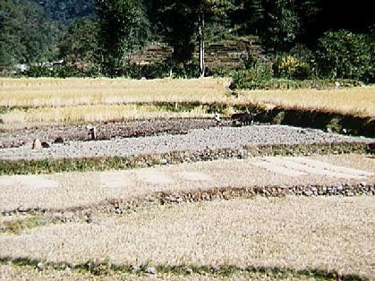
 Our first day of hiking (10/10/95) was my 32nd birthday. This town was
the end of the road and we didn't see motorized
vehicles for the next three weeks. We got some
nice views of nearby valleys, waterfalls , and a good look back
at Besisahar and the terraced rice
fields. The trail wound through rice paddies and
thick forest, occasionally crossing small and
large bamboo bridges.
Our first day of hiking (10/10/95) was my 32nd birthday. This town was
the end of the road and we didn't see motorized
vehicles for the next three weeks. We got some
nice views of nearby valleys, waterfalls , and a good look back
at Besisahar and the terraced rice
fields. The trail wound through rice paddies and
thick forest, occasionally crossing small and
large bamboo bridges.
The trail follows the Marsyangdi Khola for the
first half of the circuit. At the next big town,
Bhulbhule the trail
crosses the river for the first time on a large
suspension bridge. It was quite hot and humid,
and Catherine and Sally were feeling poorly. They decided to hire a
porter, Doot, and let him take half of each of their loads. I ended up
being the only one in our group who hiked with a full pack, but I had
the most hiking experience of the group.
The second half of the day was easier until the final grunt climb to
Bahundanda(4300') that nearly killed us all. We arrived late, and found some
beds in one of the few hotels with any left. A cool shower and
a nice meal with trekkers from all over made a fine end to the first day
on the trail.
Day 2: Bahundanda to Chamje 10/11
 Now we began to get into the rhythm of trekking. Waking up each morning
around 7:00, having a quick breakfast of Tibetan bread and tea, then
heading out. I usually left earlier than the rest of my group, getting
some good hiking done in the cooler morning and taking a bit of rest
around 10:30 for them to catch up. This day started with a 600' descent
before beginning the days climb. Along the way I observed some great
trail construction, and places where the trail
ran right across rock slides. A huge amount of
work goes into keeping the trail up.
Now we began to get into the rhythm of trekking. Waking up each morning
around 7:00, having a quick breakfast of Tibetan bread and tea, then
heading out. I usually left earlier than the rest of my group, getting
some good hiking done in the cooler morning and taking a bit of rest
around 10:30 for them to catch up. This day started with a 600' descent
before beginning the days climb. Along the way I observed some great
trail construction, and places where the trail
ran right across rock slides. A huge amount of
work goes into keeping the trail up.
We crossed back over the Marsyangdi and
continued through thick forest in a deep valley
until reaching Chamje(4560'), a small collection of hotels. We had a hot
shower (a bucket of hot water and a cup), a good dinner, and crashed
early.
Day 3: Chamje to Bagarchap 10/12
 Again, I left early, but my ankle was bothering me a bit, so I walked
slowly and the rest of the group soon caught up. We were climbing
steadily and soon came to Tal(5460'), which is Nepali
for 'lake'. There was a natural dam on the river that formed a small
lake with an actual beach, and a nice waterfall on the other end of
town. We stopped for an early lunch and I soaked my ankle in the
stream, which made it feel much better.
Again, I left early, but my ankle was bothering me a bit, so I walked
slowly and the rest of the group soon caught up. We were climbing
steadily and soon came to Tal(5460'), which is Nepali
for 'lake'. There was a natural dam on the river that formed a small
lake with an actual beach, and a nice waterfall on the other end of
town. We stopped for an early lunch and I soaked my ankle in the
stream, which made it feel much better.
We crossed the river again on a small bridge
and climbed to Bagarchap(6900'). The people here were Tibetan, and the town
had a huge 4 foot diameter prayer wheel in a
gompa with beautiful religious paintings on
the walls. There also was a large prayer wheel wall
that you spin as you walk past. You always walk past them on the left,
so you spin them with your right hand. Never use your left hand.
Day 4: Bagarchap to Chame 10/13
 After Bagarchap, we were climbing much higher and into much
drier terrain. The trail was headed into the
rain shadow of some major peaks, and we were reaching higher altitudes..
The river was getting significantly smaller
the higher we went. We also started getting some pretty nice views
of major peaks.
After Bagarchap, we were climbing much higher and into much
drier terrain. The trail was headed into the
rain shadow of some major peaks, and we were reaching higher altitudes..
The river was getting significantly smaller
the higher we went. We also started getting some pretty nice views
of major peaks.
Chame(8580') was a pretty major town, with a bank, electricity, and most
importantly, a hot spring. It was pretty small and quite crowded, but
welcome none the less. From our hotel there was a great view of
Lamjung Himal.
Day 5: Chame to Pisang 10/14
 Early the next morning we got more nice views of
Lamjung Himal and I headed out early with Doot. I had soaked my ankle
the previous night and felt good, but figured I'd start early to make
sure. My ankle felt fine, but it could have been the fantastic views
of
Annapurna II that were helping me along. We
gathered together at a small village for a rest
and spun the wonderful prayer
wall before Sally and I headed out ahead.
Early the next morning we got more nice views of
Lamjung Himal and I headed out early with Doot. I had soaked my ankle
the previous night and felt good, but figured I'd start early to make
sure. My ankle felt fine, but it could have been the fantastic views
of
Annapurna II that were helping me along. We
gathered together at a small village for a rest
and spun the wonderful prayer
wall before Sally and I headed out ahead.
This next section of trail was the most spectacular we had seen so far.
To start, a big section of the trail was blasted out of the rock. Then, as we turned the
corner we saw the Granite Wave, a 2000' cliff
of rock that dominated the area. As soon as we got over that we looked
behind us and saw fantastic views of Lamjung
Himal.
 Soon the trail started climbing and then the terrain started to
look like the Sierra. Sally and I stopped
at this wonderful tea house to eat lunch and take a nap. Catherine,
Peter, Doot, and Dharma showed up an hour later and we all pushed on
to Pisang. Along the way we got our first glimpse of
Pisang Peak.
Soon the trail started climbing and then the terrain started to
look like the Sierra. Sally and I stopped
at this wonderful tea house to eat lunch and take a nap. Catherine,
Peter, Doot, and Dharma showed up an hour later and we all pushed on
to Pisang. Along the way we got our first glimpse of
Pisang Peak.
It was still early so we decided to explore Pisang. We got a hotel in
Lower Pisang(10,280') and then hiked up to
Upper Pisang(10,600')
to see the gompa, a temple at the very top
of the town. Upper Pisang was very old, with
windy little paths and
houses one atop the other. The gompa had a
stunning temple that we viewed. From the
terrace in front there was an excellent view of Lower Pisang.
Day 6: Pisang to Manang 10/15
 I woke up before dawn and hiked up to Upper Pisang to get some sunrise
shots Annapurna II and of
Pisang Peak. When I got back to the hotel,
everyone else had decided to take a rest day in Pisang. I decided to
head on to Manang and take my extra rest day there. There are two
routes out of Pisang, and I chose the low route. Just out of town I
passed a wonderful stupa, a large Tibetan
prayer structure. The trail started
off by climbing to a fantastic viewpoint(11,060')
of the valley ahead. There were two teashops up top, and some of the girls
running them discovered the mascot that I carried
in my pack.
I woke up before dawn and hiked up to Upper Pisang to get some sunrise
shots Annapurna II and of
Pisang Peak. When I got back to the hotel,
everyone else had decided to take a rest day in Pisang. I decided to
head on to Manang and take my extra rest day there. There are two
routes out of Pisang, and I chose the low route. Just out of town I
passed a wonderful stupa, a large Tibetan
prayer structure. The trail started
off by climbing to a fantastic viewpoint(11,060')
of the valley ahead. There were two teashops up top, and some of the girls
running them discovered the mascot that I carried
in my pack.
The trail then dropped down through some fall
foliage that reminded me of New England. I entered a
wide flat valley that was much dryer than we'd
passed through so far. Mule trains were more
common here and we got incredible views back towards
Pisang Peak. The next town was Ongre(11,060')
which has an airport and the
longest prayer wheel wall on the entire
circuit, over 250. I spun every single one.
On the final leg of the day I passed a water
powered prayer wheel; a fine example of ingenuity. Just before the
end of the day, in Braga(11,425') is a 900 year old
monastery of the Kargyupa sect of Tibetan
Buddhism. I reached Manang(11,480'), found the Yak hotel, attended the
Himalayan Rescue Association (HRA) talk on Acute Mountain Sickness (AMS)
and settled
in for the night with some Irish folks I'd met a few days earlier.
Days 7-9: Manang 10/16-10/18
 I had two days to relax and to day hike without a full pack. The first
day I slept late and then started hiking up the side of
Gangapurna. I met Fred and we hiked up some
unmarked trails until reaching a beautiful
viewpoint looking north. Then the trail climbed through the woods
to a neat herder's camp. There we met some
other hikers and had lunch, looking back across the Marsyangdi and
Manang to the Chulu range. We also got some
views north towards Thorong La, the high
point of the circuit. We then hiked over to the
glacier and down.
I had two days to relax and to day hike without a full pack. The first
day I slept late and then started hiking up the side of
Gangapurna. I met Fred and we hiked up some
unmarked trails until reaching a beautiful
viewpoint looking north. Then the trail climbed through the woods
to a neat herder's camp. There we met some
other hikers and had lunch, looking back across the Marsyangdi and
Manang to the Chulu range. We also got some
views north towards Thorong La, the high
point of the circuit. We then hiked over to the
glacier and down.
My ankle (the other one this time) started hurting on the way down and
by the time I reached the hotel I was in real pain. The rest of my
group arrived and we settled in. The next day I just sat in the hotel
and read to give my ankle a rest and by the end of the day it felt much
better. The next morning we were supposed to continue on, but
Catherine had a bad headache and was worried about AMS, so Sally and I
took another day hike, this time up the left
side of the glacier, above the bright blue
lake at the base. We scrambled down some
scree slopes to get back to town. So, I
ended up spending three days in Manang instead of two.
Day 10: Manang to Ledtar 10/19
 We tried again to leave Manang and this time we succeeded. From here
on up, the trail follows the Jargeng Khola,
a tributary of the Marsyangdi Khola. We quickly climbed through a
few villages to Yak Kharka(13,020') for lunch. The altitude gave us
excellent view back towards
Glacier Dome. The terrain was a
dry flat
dry flat plain above the river valley, as we
passed twisted mountains.
We tried again to leave Manang and this time we succeeded. From here
on up, the trail follows the Jargeng Khola,
a tributary of the Marsyangdi Khola. We quickly climbed through a
few villages to Yak Kharka(13,020') for lunch. The altitude gave us
excellent view back towards
Glacier Dome. The terrain was a
dry flat
dry flat plain above the river valley, as we
passed twisted mountains.
We reached Ledtar(13,700'), which is a collection of three hotels,
nothing else. Before dinner we spotted some Dal sheep on the hillside.
Up here is was quite cold, and we could begin to feel the affects of
sleeping at altitude.
Day 11: Ledtar to Thorong Phedi 10/20
 Again, Catherine woke up with a bad headache and wanted to stay another
day to acclimatize. Sally and I decided to press on, with plans to meet
up with Catherine and Peter on the other side of the pass. If they
didn't go over, they would hike back the way we came. We started early
because we wanted to get a nice room in Phedi. There's two hotels
there, and most of the beds are in dormitory style rooms. The hike
continued up the Jargeng Khola, before
crossing it for the last time. We climbed to
a tea house, past a herd of yaks, including some
very large individuals.
Again, Catherine woke up with a bad headache and wanted to stay another
day to acclimatize. Sally and I decided to press on, with plans to meet
up with Catherine and Peter on the other side of the pass. If they
didn't go over, they would hike back the way we came. We started early
because we wanted to get a nice room in Phedi. There's two hotels
there, and most of the beds are in dormitory style rooms. The hike
continued up the Jargeng Khola, before
crossing it for the last time. We climbed to
a tea house, past a herd of yaks, including some
very large individuals.
It was just a bit farther to Thorong Phedi(14,660'), just two hotels
in a sea of scree. The 200' steep climb to the higher hotel was very
slow, as the altitude was beginning to really sap our strength. We
arrived around 11:00 and got the last double room. Then we ate lunch,
rested, and played hacky sack with some folks staying nearby.
Day 12: Phedi to Muktinath, Over Thorong La 10/21
 We woke up at 5:00, planning to leave in the dark, but waited until
first light, about 5:45. It was quite cold, about 20 F when we started
and didn't get much warmer all morning. You could see a long line of
trekkers, hiking very slowly up the pass. The views were spectacular. We stopped to rest and
have a snack at a tea house half way up. Then
we continued the single file march on up. The
views of scree and snow just got better, and we
all were moving slowly enough to appreciate them.
We woke up at 5:00, planning to leave in the dark, but waited until
first light, about 5:45. It was quite cold, about 20 F when we started
and didn't get much warmer all morning. You could see a long line of
trekkers, hiking very slowly up the pass. The views were spectacular. We stopped to rest and
have a snack at a tea house half way up. Then
we continued the single file march on up. The
views of scree and snow just got better, and we
all were moving slowly enough to appreciate them.
As we approached the pass, we saw climbers on the
peak to the south of the pass. Finally, around
10:30, we made it! Thorong La(17,700') is the
transition from the Marsyangdi Khola to the Kali Gandaki, and into the
Mustang district. We ate chocolate, took pictures and
played hacky sack before starting the 5000'
descent. Along the way we stopped at a
beautiful hanging meadow for a snooze, then
continued on down to Muktinath(12,460'). With one last
look back at the pass, we ended our toughest
day.
Day 13-14: Muktinath to Kagbeni 10/21-10/22
 We slept late the next morning, but were woken up by a helicopter
carrying very rich Indian tourists up to the temple. Our trip for the
day was pretty short, and I wanted to spend some time in the temple
complex. The hike up from town provided some
spectacular views of Dhaulagiri. The
temples are located in a
sacred grove of trees.
We slept late the next morning, but were woken up by a helicopter
carrying very rich Indian tourists up to the temple. Our trip for the
day was pretty short, and I wanted to spend some time in the temple
complex. The hike up from town provided some
spectacular views of Dhaulagiri. The
temples are located in a
sacred grove of trees.
There's a set of 108 fountains with the spouts
carved in the shape of boar's heads. Pilgrims
wash in each one to gain salvation after death. The fountains
surround a temple full of bells that only
Hindus and Buddhists can enter. The most
important temple in the
complex houses the place where fire (natural gas) burns on water
(spring) where they come out of the ground together.
 Sally and I headed down the valley which was
dry and desolate. As we
rounded a bend we had our last view of
Thorong La. We passed though some farming
areas where the locals stored hay and firewood on the roof. We then caught a view of
Kagbeni(9200'), an ancient town that has been
involved in the salt trade for thousands of years. It blocks the
trade route coming down the Kali Gandaki from
Upper Mustang.
Sally and I headed down the valley which was
dry and desolate. As we
rounded a bend we had our last view of
Thorong La. We passed though some farming
areas where the locals stored hay and firewood on the roof. We then caught a view of
Kagbeni(9200'), an ancient town that has been
involved in the salt trade for thousands of years. It blocks the
trade route coming down the Kali Gandaki from
Upper Mustang.
If Catherine and Peter were going to catch up to us, we needed to spend
a rest day, and Kagbeni was such a wonderful town that this was our
choice. We stayed in the Dhaulagiri Hotel, a
name we would see in every town on this side of the pass. The town was
a jumble of narrow streets and
tunnels, all piled on top of each other. There
was a large monastery in the center of town.
Near our hotel was a huge stupa with a tunnel
running under it.
In the afternoon, the winds picked up and you had to go indoors. All
the hotels had glassed sun rooms because you couldn't sit on a patio.
That night we heard from some folks that Catherine and Peter had made
it over the pass, but spent an extra day in Muktinath, throwing our
schedule off. We decided to leave them some notes in Kagbeni and push
on to the next town where we could spend another rest day if needed.
Days 15-16: Kagbeni to Marpha 10/23-10/24
 We wanted to get an early start so we could cover a lot of ground
before the winds started, around noon. We hiked down the
river bed and got some more great views of
Dhaulagiri. We reached Jomsom(8900') which
has some picturesque streets, very nice
restaurants, and an airport. Many people fly into Jomsom and trek
down river back to Pokhara.
We wanted to get an early start so we could cover a lot of ground
before the winds started, around noon. We hiked down the
river bed and got some more great views of
Dhaulagiri. We reached Jomsom(8900') which
has some picturesque streets, very nice
restaurants, and an airport. Many people fly into Jomsom and trek
down river back to Pokhara.
After lunch, we bundled up to protect from the wind and continued down
river. We reached Marpha(8750'), perhaps the
nicest trekking town on the whole circuit. We checked into our hotel
and ate some more wonderful food. Now I was beginning to see why this
part of the trip was known as the Apple Pie Circuit. There were fresh
apples, apple brandy, and something resembling pizza.
To let Catherine and Peter catch up we took another rest day in Marpha.
The town had a magnificent paved street
running down the center with a water culvert underneath. The side
streets were narrow but more open than Kagbeni. At one end of town was
a beautiful mani wall. The rest of our
group arrived that afternoon and we were together again.
Days 17-18: Marpha to Lete to Tatopani 10/25-10/26
 I had decided that I wanted to push on to the Annapurna Sanctuary, which
would require 7 days of hard hiking. The rest of the group was going to
take it easier, so I was on my own. We hiked together for the morning,
past mountain views to the town of
Tukche, just below Dhaulagiri. We continued on
a bit farther and had and early lunch. Since I still had a long day,
I bundled up against the wind and headed out on
my own. There were clear views of the Nilgiri Range
across the river bottom. As the trail fell, I started seeing more
fields and signs of agriculture.
I had decided that I wanted to push on to the Annapurna Sanctuary, which
would require 7 days of hard hiking. The rest of the group was going to
take it easier, so I was on my own. We hiked together for the morning,
past mountain views to the town of
Tukche, just below Dhaulagiri. We continued on
a bit farther and had and early lunch. Since I still had a long day,
I bundled up against the wind and headed out on
my own. There were clear views of the Nilgiri Range
across the river bottom. As the trail fell, I started seeing more
fields and signs of agriculture.
I stopped in the town of Lete (8100') and found myself as the only guest in a
large hotel. During dinner that night, two men came in. They had just
summited Dhaulagiri and were on their way back home to Bulgaria. We had
a nice time communicating as best we could about climbing. The next
morning there were excellent view of Daulagiri
and Tukche Peak.
I pressed on to Tatopani, my goal for the day. The Kali Gandaki cut
deeper as the trail went south. After passing
the town of Ghasa (6700'), the
old trail was visible on the other side of the
river, and it was obvious why it was abandoned. The
valley broadened a bit, and I passed a beautiful
waterfall.
As I approached Tatopani (3900') the locals were
harvesting rice along side the trail. There
were banana trees reaching over the trail as
I passed the hydro electric plant that supplied
power for the region. The name Tatopani means hot water, and there are
wonderful hot springs along the river. I fainted after going all day
without much food, not drinking enough water, and then taking a dip in
the hot springs. Don't try this at home!
Days 19-20: Ghorepani, Poon Hill, and Chomrong 10/27-10/28
 The climb to Ghorepani is around 5000', so I got a good early start and
took it easy all day. After a few hours I had climbed out of the deep
valley and got some good views back up river.
It was hot, so I stopped often for water and snacks. There
were people who rented horses for the climb. Both the trekkers and the
horses looked miserable, and I ended up finished before them anyways.
In the hilly terrain, one of the main crops
was corn.
The climb to Ghorepani is around 5000', so I got a good early start and
took it easy all day. After a few hours I had climbed out of the deep
valley and got some good views back up river.
It was hot, so I stopped often for water and snacks. There
were people who rented horses for the climb. Both the trekkers and the
horses looked miserable, and I ended up finished before them anyways.
In the hilly terrain, one of the main crops
was corn.
I finally reached Ghorepani (9250') after a long hot day. I checked
into a hotel in the center of town, but if I knew better I would have
found a place farther up the hill where the views were better. That
night we watched a beautiful sunset over
Annapurna I and Annapurna South.
It is almost mandatory that you wake up before dawn and climb the 1000
feet to Poon Hill (10,478') so you can see an unobstructed sunrise. So,
I woke up
at 5:00AM and started up by headlamp. It took 30 minutes or so, and
people had started gathering already. As the
sun came up we first had a view of Annapurna
South, and then the entire Annapurna Himal.
I had some friends take a picture of me to
remember to occasion. Then Dhaulagiri came
fully into view. I highly recommend the experience.
So, it was back down to Ghorepani, eat breakfast, pack up, and start
the longest day of the trip. I met up with two other Americans and
we started out. We climbed a hill with good views back towards
Poon Hill and then dropped down to Deurali
(10,160), then climbed up and mostly down to Tadopani (8800'). Along
the way we went through thick forests and
rough hills. Because this area is more heavily
travelled, we saw more guided, tent trekkers and their
severely overburdened porters.
We stopped for lunch in Tadopani, with gorgeous views of
Machapuchre. But we still had a long way to
go, so we headed off, dropping down to a river crossing then up a
big climb. Few trekkers go this route, so the trail was much less
established. We crossed the side of a hill, pausing to observe the
flowers and farms
along the way.
I finally arrived in Chomrong at
around 4:00PM, exhausted but having
reached my goal for the day. This was the hardest day of the entire
trip, and it meant I would be able to make it to the Sanctuary and
out on time. I watched sunset over Annapurna
South as I collapsed in my bed.
Days 21-23: The Sanctuary 10/30-11/1
 The next day started with a big drop down to the bottom of Chomrong
and a big climb up the other side. The valley
was steep walled, with some specatular waterfalls
cutting through the sheer rock faces. There are a few
lodges along the way, but several have been
relocated to cut down on the damage to ecosystem. I hooked up with a
Swedish woman, Annelie, as we left Chomrong and we hiked together for
the next few days.
The next day started with a big drop down to the bottom of Chomrong
and a big climb up the other side. The valley
was steep walled, with some specatular waterfalls
cutting through the sheer rock faces. There are a few
lodges along the way, but several have been
relocated to cut down on the damage to ecosystem. I hooked up with a
Swedish woman, Annelie, as we left Chomrong and we hiked together for
the next few days.
We spent the night in Himalya, a collection of two guest houses in
the middle of nowhere. The next day was a little cloudy, but we had
occasional good views up and
down the valley. A little after noon we hit
Machapuchre Base Camp, or MBC. We stopped for
lunch and to get out of the cold. Then pushed on to
Annapurna Base Camp, the heart of the santuary.
We grabbed the last bunks in a triple room with a ex-pat Brit living
in Spain. The crowd was festive, but it was cold and snowing, so we
spent most of the afternoon in the main room with a heater cranking
under the table and lots of tea.
 ABC is a collection of stone huts surrounded by
mountains and glaciers at around 14,600'. The main
peaks right
behind ABC are Annapurna South,
Annapurna I, and Hinchulli, but you can also
see Machapuchre, Tent Peak, and
Annapurna III. We spend a raucus Holloween in
the dining room, with Marcel playing cards with the porters for money.
Too bad he didn't understand the game he was playing. Needless to say,
he lost.
ABC is a collection of stone huts surrounded by
mountains and glaciers at around 14,600'. The main
peaks right
behind ABC are Annapurna South,
Annapurna I, and Hinchulli, but you can also
see Machapuchre, Tent Peak, and
Annapurna III. We spend a raucus Holloween in
the dining room, with Marcel playing cards with the porters for money.
Too bad he didn't understand the game he was playing. Needless to say,
he lost.
The next morning everyone woke up for sunrise, but it wasn't that
special, covered with clouds. I got a photo of
myself and one of
my mascot before leaving. We all hiked a short
ways above ABC to get some perspective. Then
we headed down as the weather cleared. We saw
the high, rocky valley that we'd climbed the day
before but couldn't see. We didn't stop at mbc
on the way down, but pushed on, back into bamboo
forests.
We stopped in Bamboo, the first town inside the santuary. It was nearly
a 5000' drop, the same as coming over the pass. Everyone was beat, and
no one was sure where we were going the next day. The sanctuary was
spectacular, and the weather was clearing again, but everyone felt that
we were on our way out, regardless of speed.
Days 24-25: Out to Pokhara 11/2-11/3
 We woke up early and Annelie decided to take it slower. We hiked out to
the Santuary checkpoint and then split up. We got some real nice
view back to Machupuchre as we bid the
Sanctuary goodbye. Ahead of me was the drop and climb to Chomrong, up
the most amazing stone steps, climbing 1500'
straight up. By the time I reached the top of the hill I was beat. I
decided to head out along the river, via a trail that wasn't on any of
the maps. Fortunately I ran into two trekkers headed the same way and
we joined forces.
We woke up early and Annelie decided to take it slower. We hiked out to
the Santuary checkpoint and then split up. We got some real nice
view back to Machupuchre as we bid the
Sanctuary goodbye. Ahead of me was the drop and climb to Chomrong, up
the most amazing stone steps, climbing 1500'
straight up. By the time I reached the top of the hill I was beat. I
decided to head out along the river, via a trail that wasn't on any of
the maps. Fortunately I ran into two trekkers headed the same way and
we joined forces.
First we dropped to the river and the rest of
the trip was out along it. The trail was there, but not very heavily
used. It brought us to a single lodge in the middle of nowhere, still
several hours from the road so we crashed there. The town was called
Kyumi and it looks like it was used mostly by big tenting groups.
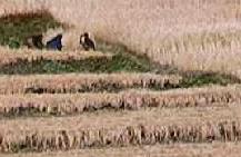
The next days hike out was gentle and relaxing, passing through
terraced fields and
rice paddies. We did see some porters
hauling kayaks for some folks who were going to
run the Mondi Khola. We hit the road in Berithanti and caught a taxi
back to Pokhara and I was back in the hotel by 2:00. It was a big
culture shock, reaching civilization again, and then realizing that
Pokhara was now civilization.
The rest of my group arrived later that day. They had made it to all
the places they wanted to go, but it was cloudy the day they were on
Poon Hill so no one when up. It was a fantastic trip, I'd recommend it
to anyone.
Back to White Mountains home page